TCAT
The Island - Continued (Page Two)
Following the Bamfield/ Franklin River road N.E. will take you to Port Alberni, a center of close to 20,000 people... Port Alberni started as a mill town producing paper and lumber for export, it also serves as a center for fishing, logging aa well as farming in its broad valley... At the head of the Islands deepest fjord Port Alberni has the warmest summertime temps on Vancouver Island with highs often reaching and staying in or above the 30 C range for days on end in the summer.
While in Port Alberni there are plenty of places to stop for supplies, grub and fuel.. The track will take you out of town on Johnston RD which becomes the Alberni HWY, you will stay on this RD for a couple KM and then turn left on Cherry Creek Rd.. After a couple jogs onto side roads you will see the powerline come into view, the track loosely follows the powerline up the mountain in a series of dirt road switchbacks.. This is one of the more difficult sections of the Island TCAT as the trail swings back and forth gaining about 1000 ft of elevation in a short time... Those that feel this section is to difficult can backtrack to the HWY and follow it to the Alberni Summit and the Cameron main crossing... If you take the a left off the hwy onto the Cameron main dirt road it will join into the TCAT further along, avoiding the rough sections of the powerline climb... Sometimes the gate is closed at the bottom of the powerline climb so you will have to backtrack either a km back from the way you came and access the rail trail along the base of the mountain to join the track above the gate or go back to the hwy to the above described Cameron main easy route.. The last time I rode the powerline climb track it was very rough...

Powerline Climb

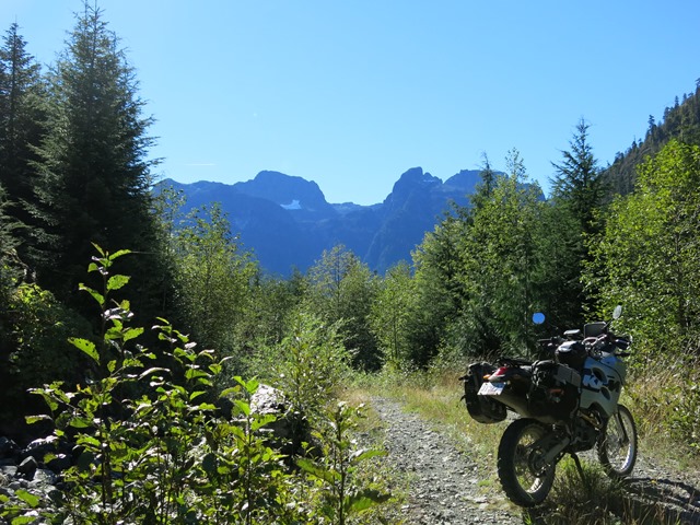
After the powerline climb you will follow the Horne Lake connector road towards the Horne Lake FSR Junction, this road offers some nice scenery along the way.

Scene from the Connector Rd
At the Horne LK FSR junction turn left and follow a small river towards the Cook Creek FSR, there is a couple camping slots along this river and a very nice waterfall to watch for.

Falls

Staying on track this route takes you through some very nice winding roads through the forest and rises out of one watershed and then follows another {Cooke Creek} towards Georgia Straight giving some nice views.

Chrome Island Lighthouse

The track will eventually take you across the 4 lane hwy 19 and down to 19A where you will follow the coast route for about 30KM to Royston and then turn left on Royston Rd and onto Cumberland.

Downtown Cumberland
Cumberland is one of the oldest towns on Vancouver Island with some very old architecture shown in its stone buildings... In the late 1800s this place was a bustling coal mining center which boasted a large China town and the terminus to the Vancouver Island Railroad... I would recommend you top up with fuel and supplies here as it will be approx 140 km to the next gas.
The track heads out of Cumberland on Bevan Road for a few KMs and then turns right on Comox lake Road for another few KMs before crossing an overpass and then turning left on Duncan Bay main.... Before the overpass look for some point of interest ruins in the woods on the right side of the road.

Mining Ruins
Duncan Bay main takes you across the Puntlage and Browns river bridges before crossing another overpass on the way to the Mount Washington RD crossing... The road up to Mount Washington makes for an interesting side trip with great views and amounts to about a 20 km detour... After the Mount Washington Crossing the road surface turns to gravel and one should be on alert for logging trucks... The road passes by Wolf Lake and on the Northern end there is a lakeside pullout area.

Wolf Lake
A few KMs up the road from Wolf Lake the track turns off on a trail to the left where you cross a creek and continue on some narrow roads.. Look for Elk along this stretch.

Elk Herd
Near the Oyster River the track returns you onto Duncan Bay main for another 10 KM or so and then takes a hard left onto Elk River Main.
Elk River main will take you past a few lakes on the way to HWY 28, the last lake is Echo Lake which is right at the HWY 28 Elk River Junction... Once you cross hwy 28 you are now leaving the South Island section and on to the North Island TCAT.
North Island TCAT
The track follows along Elk River Main RD and then takes a trail to the right just before Beavertail Lake.. This trail takes you through some forested paths right to the Strathcona Dam crossing.

forested path
Upper Cambell Lake
Dam pic# 0628
After you cross the Dam the track takes you into some nice winding forest paths all the way to Fry/Lower Cambell lakes.
Lower Cambell Lake campsite pic# 058 + #060 photo credits to Lane Detoit
You will come off Greenstone road at a T junction onto Patterson where the GPS track goes left, there are plenty of Camping spots along Campbell Lake if you stray off track to the right...
Taking the track left along Patterson puts you on a narrow forest track the winds its way past some small lakes, eventually bringing you to the Patterson Lake which has a couple camping areas along the lake.


Along Patterson main

Patterson Lake

Continueing past Patterson Lake the track will take you to the Upper Salmon road Junction where you turn left and follow the Salmon River up the Canyon.. Almost right away you will come upon the Salmon Viaduct and the river bridge and will start to gain elevation along the River Canyon.

Salmon Viaduct

Salmon Canyon

Staying on track you will come up to some small lakes on the right and left, these lakes also have some small camping areas, the water in these lakes is a bit murky so you may want to treat it first.

Murky Lake
After the Lake a couple right turns take you onto to Cooper Creek Rd which is a nice overgrown path.

Cooper Creek summer

In the winter
Cooper Creek takes you down to Memekey Main where you turn right and follow it to Big Tree main where you turn left.

Big Tree Junction
Big Tree main does a lot of winding for 4 -5 KM before coming up to the left turn onto Salmon/Airstrip Main... Almost as soon as you turn onto this road you'll cross a bridge over the Memekey River, look for a nice camping spot along the river on the North side of this bridge.

Memekey Campsite
After the bridge you'll come onto a very long, wide and fast gravel straight that runs without the slightest bend for 4 KM, this is rumored to have been built as a landing site for large aircraft during the war... Continue on the Salmon main to where the track passes some rural homes, if you need fuel at this point you can nip along a little further accross the bridge then turn right for a 1 KM and come out at Sayward Gas station, there is a Restaurant/Pub and ice cream stand close by... You may want to nip down the Valley Rd for about 10 km to see the village centre on Johnstone straight before returning to pick up the track where you left it past the bridge.
Sayward is a small farming and logging community that represents the pioneer days of the B.C. logging industry... It is also the area where a tree planting silviculture program was first introduced in B.C. after a huge fire in the 1920s took out the forests from Sayward to Cambell lakes. A lot of those trees on the Cambell to Sayward stretch of the track were planted during this first program and have come a long way and a lot of them are going a long ways on ships to the mills in China.
Sayward forest District is a bit of a thorn as the area forest company forced the workers into taking a 7 day a week logging schedule by offering them the choice of having no job or taking whats given to them... At the same time other districts like Port Mcneill were bullied into taking the same deal but resisted and fought it so they still have their weekends now...
So because of the 7 day a week logging the best time to transit through Tlowils/Adams mains is in the evening after working hours... In the dry part of summer the logging switches to early shift so by mid afternoon say around 3 ish the roads are usually empty and safe for travel... If you travel up this main during working hours use extra caution as there are a lot of narrow bends.
Just out of Sayward the track takes a left and starts a climb into the mountains, Tlowis lake will come into view and you will then ride past it.. The track will do a sharp right and return to follow the West Edge of the lake and then spit you out onto Adams main where you head up the mountainous valley... The next 30-40 KM will be the most Scenic of the Vancouver Island TCAT with many short side valley vista options.
Adams Valley
Take the left fork onto Upper Adams at the Compton Creek Bridge and Continue through Schoen Park and onto Gerald Creek.. Moakwa Creek makes an interesting side trip to the Glacier and mountain waterfall vistas.


Moakwa Valley Sideroad
After the road passes the Moakwa Valley it starts to drop as it takes you down to the White River Valley and then you get your firs glimpses of Victoria Peak.. They have also decided to put the Spine "hiking" Trail through this scenic valley as well


Victoria PK
As you ride along past Victoria Peak you will come to a fork , the track goes left, but if you take a short jaunt to the right you can get a real nice vista by riding up Kukumi RD and looking back at Victoria Pk.


Victoria Glacier
Back on track you take the fork across the river then take a 90 degree right turn up the valley towards a box canyon.
Once you get farther up the Valley Victoria road ends on Stewart Road so the track does a right on Stewart takes you back to White River Main to continue up the Valley and around Victoria PK...

Above and below: Victoria PK

The track goes past the mountain and then does a 90 left across the river then a 90 right on its way up towards a box canyon....

Box Canyon

Above and below: White Gold Pass summit

Before you get to this box canyon the track follows a choppy spur to the left that takes you up over White /Gold pass on the right side of that valley... The Summit of this pass is just below 3000' and is sometimes snowed in till late June but often passable around the 3rd week in May... Near the top of the pass is a small gate that always seems to be open, this gate represents the logging boundry, once past this gate your back in a weekends free of logging activity area... Just down the road from the pass you’ll come to a large stand of trees, look for a trail that goes through the big trees to the left... This path is a bit of a rough track that takes you near the edge of Twaddle Lake where you could pitch a tent for the night in the forest...
Below next 3 photos: Twaddle Lake


The track follows the mainline {East/West Gold} right down to Nimpkish Main where it turns right... From this point a side trip to Tashis should be considered, if the weather is nice the Tahsis road is one of the best rides on Vancouver Island if it is raining save this for the next time...
Chapter Link: Tahsis Distance- Approx 70 KM one way 140 KM return...
Where the TCAT track down from White/ Gold pass turns right on Nimpkish Main, you continue straight instead on East Gold to head to Tahsis... After approx 7 KM you will reach the Gold River/ Tahsis junction, if you need fuel it would be wise to top up in Gold River before continuing... Almost immediately after leaving the junction the road takes a right fork and starts to climb up the Upana valley and alongside the river in spots... You'll pass Cala falls on the way to Summit lakes before the road starts to drop over the pass, in late spring both sides of this section can be lined with 5' walls of snow that makes for a very interesting ride... The road runs like a roller coaster with mixed pavement and gravel for the first half and you'll pass a nice camping spot at Conuma river a few KM before you reach Head bay right off the left side of the road... The track continues on past inlets, rivers, lakes and just before Malaspina lake, a road to the left takes you to a nice camping spot on the far side of the lake... The track continues on and you hit some long straight paved sections, look for a camping area to the left along this section at the Leiner River... Just a few KM after the Leiner River campsite you round a bend and Tahsis comes into view at the head of Tahsis inlet... Tahsis is a small Hamlet of around 500 + - depending on season... It has a small store, a couple of restaurants , a fuel station and a very nice campground at the far end of town along the ocean... Like many places on the North Island Tahsis was once a thriving town with a large sawmill that operated for quite a few years at the head of the inlet... At that time the population was around 2000 people and that supported many businesses and stores, but as the story goes, the mill shut down and the people left...
Next 3 photos: Tahsis Road


Summit Lake

Conuma River

Tahsis Village